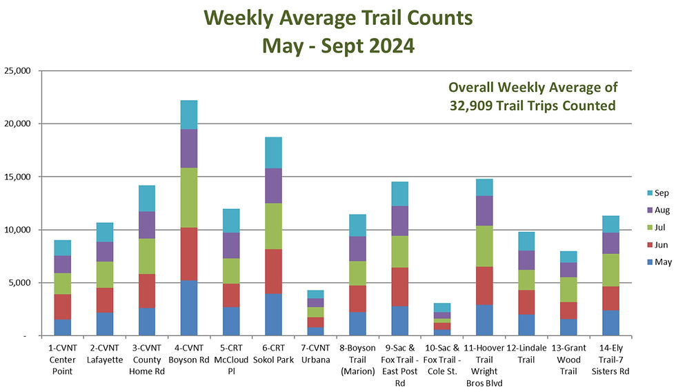
LCTA has installed infra-red (IR) counting devices on several trails within Linn County to determine usage. The results are shown in the following plots of daily counts. The counters are read frequently by LCTA supports and the data are interpolated to allocate the counts on a daily basis. The consistency of the daily counts demonstrates the validity of the data. If two people are walking or biking side-by-side, only one count is recorded. Testing has demonstrated an approximately 10 percent undercount but the amount will vary depending on the type of trail traffic. However the data presented here does not contain an undercount correction. This represents a conservative estimate of trail usage. Gaps in the plot data are periods where data were not available due to battery failure or other problems.
We rely on trail users to read and report the counts on displayed on the counter posts. To report a count, go to linncountytrails.org/trailcount and enter the data on the form. You may enter the data on your smart phone while on the trail or back home with your computer.
Click here for a map of the trail counter locations.
The infrared counters were designed and built by Rockwell Collins Retiree Volunteers (RCRV) lead by Dick Kittrell. Details about the counters including circuit diagrams are available at rcrv.org/community_projects.php?projID=145.
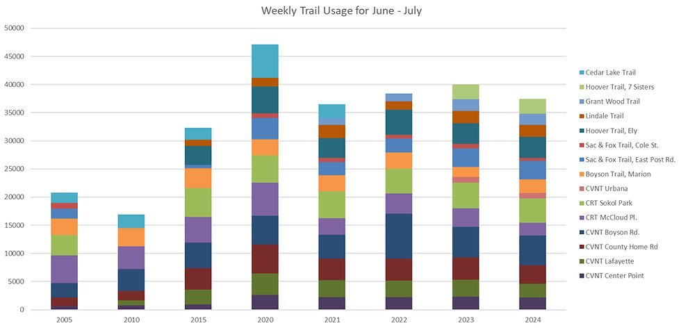
Peak trail usage occurs during June and July. There is a significant usage dropoff after RAGBRAI on the last week of July. Average weekly trail usage at each trail counter has been collected for June through July since the trail counters were installed.
Click to download a table summarizing peak season trail usage
In contrast to the peak season, the usage for the fall and winter months with cold and snow is also shown for 5 years.
Weekly Trail Usage for Sept-Dec
Trail | 2005 | 2006 | 2007 | 2015 | 2016 |
---|---|---|---|---|---|
CRT Sokol Park | 1,215 | 1,096 | 1,820* | 1,747 | 3,572 |
Cedar Lake Trail | 891 | 871 | 907 | 1,037 | 1,276 |
CRT McCloud Pl. | 1,639 | 1,424 | 1,521 | 1,151 | 1,850 |
CVNT Boyson Rd. | 1,039* | 1,026 | 1,133 | 1,456 | 1,793 |
CVNT County Home Rd. | 601* | 712* | 748* | 1,932* | 1,882 |
CVNT Lafayette | 404* | 379* | 408* | 1,084* | 1,411 |
CVNT Center Point | 406* | 282* | 215* | 784* | Paving |
Marion Trail, Boyson Rd. | 1,461 | 1,721 | 1,375 | 1,611 | 1,699 |
Sac & Fox Trail, East Post Rd. | 982 | 1,346* | 1,249* | - | 1,222 |
Sac & Fox Trail, Cole St. | 440 | 346* | 468* | 601* | - |
Hoover Trail, Ely | 1,729* | 986 | |||
Lindale Trail | 873 | 627 | |||
* Counts for Sept-Nov only |
The trails were significantly impacted by the flood of 2008. The trails are now restored. The Sac and Fox Trail was closed after the flood in early June 2008. The south end of the Cedar River Trail from Sokol Park south was also closed and was impassable. The trail counts at Sokol were much lower than prior years. The Boyson Trail in Marion was impacted by the flood but was quickly restored. However the Cedar Valley Nature Trails in Linn County were not impacted by the flood and the 2008 counts were up significantly compared to prior years. The average weekly count for 2008 July and August at the trail head on Boyson Road for the Cedar Valley Nature Trail was 53% more than in 2007 or an average weekly count of 4,680. Trail users have simply moved to to the remaining active trails!
Daily trail usage plots are available for twelve locations on the the trail system within Linn County. Click on the right side bar to see the plots, The Cedar River Trail (CRT) is a North-South hard surfaced trail through Cedar Rapids and Hiawatha. The Cedar Lake Trail is a small loop trail near the middle of the CRT. The CRT connects to the Cedar Valley Nature Trail (CVNT) which continues to the Waterloo/Cedar Falls area. The four counters on the CVNT are at mile 0 (Boyson), mile 3 (County Home Rd.), Mile 7 (Lafayette) and Mile 13 (Center Point). Before 2013, the trail was crushed limestone past County Home Rd. In 2013 it was paved past Lafeyette. Since 2017 the CVNT trail is hard surfaced to through Center Point. Therefore the counter at County Home Rd. indicates the number of users that continued onto the crushed limestone surface prior to 2013. Lafayette is a popular turn-around point for many CVNT users. It is interesting to observe the traffic reductions as the distance from central Cedar Rapids increases, however a significant number of users continue beyond the hard surface. Notice the increased counts after the paving was completed through Lafeyette in 2015 and Center Point in early 2017. The Hoover Trail continues south from the Cedar River Trail to the city of Ely. Other unconnected trails which have crushed limestone surfaces are the Boyson Trail and the Sac and Fox Trail. The counters are at the two ends of the Sac and Fox trail. Lindale Trail was opened in late 2013 and paved in early 2014. Lindale Trail extends from C Ave NE to Boyson Trail in Marion.